By George George Idowu
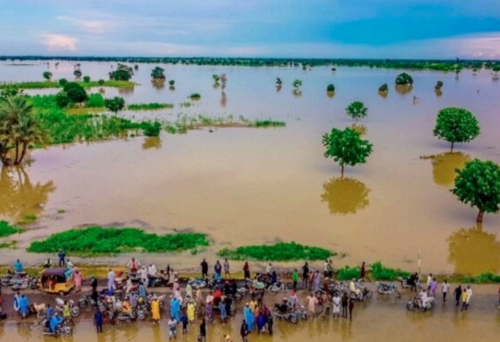
The Nigeria Hydrological Services Agency (NIHSA) has raised alert over the rising water level in the River Niger system, cautioning the public to stay alert to the potential for flooding.
The agency noted that floodwaters from upstream activities in Niger and Mali are gradually flowing towards Nigeria, beginning in Kebbi State.
NIHSA Director-General Umar Mohammed explained this in a statement released at weekend.
This situation, according to him, is being monitored based on reports from the Niger Basin Authority (NBA) in Niamey, Niger Republic.
He said: “Dam operators at Kainji and Jebba, both located on the River Niger, have been notified and are prepared to act.
“As of August 22, NIHSA confirmed that these dams are not currently releasing water from their reservoirs,” he added.
Umar warned that the risk of flooding is anticipated to peak by the end of August and continue into September.
He therefore urged states and communities along the River Niger system to remain vigilant and take necessary precautions.
He also assured the public that NIHSA would closely monitor the situation and provide regular updates as conditions evolved.
Niger River is the principal river in West Africa sub-region with a length of 2,600 miles (4,200 km). It is the third longest river in Africa, after the Nile and the Congo.
The Niger River is used for irrigation, power production, and transportation. lts lower stretch irrigates savannas, provides hydroelectricity, and serves as a transportation artery.
The Niger River rises in Guinea at 9°05′ N and 10°47′ W on the eastern side of the Fouta Djallon highlands, only 150 miles (240 km) inland from the Atlantic Ocean. Issuing as the Tembi from a deep ravine 2,800 feet (850 metres) above sea level, it flows due north over the first 100 miles (160 km).
It then follows a north – easterly direction, during the course of which it receives its upper tributaries -the Mafou, the Niandan, the Milo, and the Sankarani on the right and the Tinkisso on the left—and enters Mali.
Just below Bamako, Mali’s capital, the Sotuba Dam marks the end of the upper river. From there the Niger once dropped more than 1,000 feet (300 metres) in about 40 miles (60 km) into a valley formed by tectonic subsidence; but the rapids in this stretch have been submerged by the waters backed up by the Markala Dam, located some 150 miles (240 km) downstream of the Sotuba Dam near Sansanding.
In this stretch, at Koulikoro, the river takes a more east-north-easterly direction, and its bed becomes fairly free from impediments for about 1,000 miles (1,600 km).
It continues its movement from this location joining by tributaries, lakes, creeks and backwaters and passes through countries and Navigates itself through the southern fringe of the Sahara flows into neighbouring Niger Republic into Nigeria and continues to be navigable to the Atlantic Ocean.
Navigation on Niger River is seasonal because of the fluctuations in the water level in the rainy and dry seasons.
Meanwhile, downstream from Jebba, in Nigeria, the Niger River enters its lower course, flowing east-southeast through a broad and shallow valley 5 to 10 miles (8 to 16 km) wide.
About 70 miles (110 km) from Jebba it is joined by the Kaduna River —an important tributary that contributes about one-fourth of the annual discharge of the river below the Niger-Kaduna confluence—and about 25 miles (40 km) above Lokoja the river turns to the south.
At Lokoja the river receives the water of its greatest tributary, the Benue, thereby approximately doubling the volume of its annual discharge. At their confluence the Niger is about three-fourths of a mile (1 km) wide, and the Benue more than a mile. Together they form a lake like stretch of water about two miles wide that is dotted with islands and sandbanks.
From Lokoja downstream to the town of Idah, the Niger flows in a restricted valley, enclosed by hills and in some places flanked by sandstone cliffs up to 150 feet (45 metres) high.
Between Idah and Onitsha the banks are lower and the country flatter. At Onitsha, the largest town on the Niger’s banks in Nigeria the river flows through what is probably a fault in the area’s sandstone. It emerges at Aboh, separating into many branches before reaching the Gulf of Guinea via Africa’s largest delta popularly known as Niger Delta region.
Map of Nigeria shows the states in the Niger Delta region to includes Aba, Akwa lbom, Bayelsa, Cross River, Delta, Edo, Imo, Ondo and Rivers State.